


Grossglockner High Alpine Road: Complete Guide to Austria’s Highest Peak (2026)
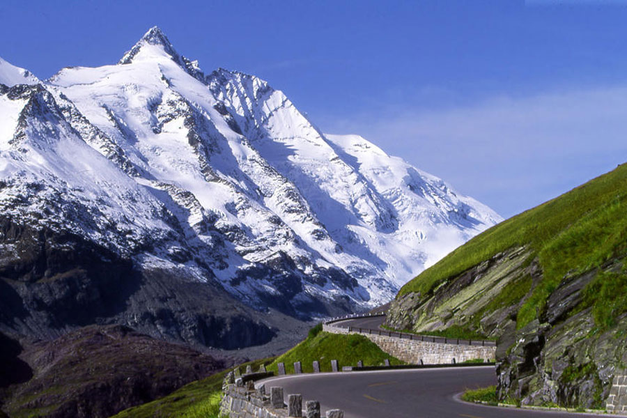
Grossglockner is Austria’s highest mountain at 3,798 meters, and the Grossglockner High Alpine Road (Grossglockner Hochalpenstrasse) that winds through the national park beneath it is one of Europe’s most famous scenic drives.
Height: 3,798 meters (12,461 feet), Austria’s highest peak.
Location: Situated on the border between Carinthia and Tyrol, within the Hohe Tauern range.
Glacier: Home to the Pasterze Glacier, the longest glacier in Austria.
Alpine Road: Famous for the Grossglockner High Alpine Road, one of Europe’s most scenic mountain drives.
Mountain Range: Part of the Hohe Tauern range within the Austrian Alps.
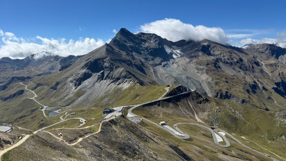
The Road: 48 kilometers long with 36 bends, reaching a maximum altitude of 2,571 meters at the Edelweissspitze, the highest point accessible by public road in Austria.
Toll: €46.50 per car (summer 2026 rate), valid as a day pass covering all viewpoints and the glacier road spur, not a single-journey fee.
Season: Open roughly late April/early May through late October or early November, weather dependent, closed to traffic in winter.
Route and Viewpoints
The High Alpine Road runs between Fusch (north) and Heiligenblut (south), with two signature spur roads. The Edelweissspitze spur (about 2 km) climbs to the road’s highest point at 2,571 meters, offering a 360-degree panorama over the surrounding peaks. The Kaiser-Franz-Josefs-Höhe spur (about 9 km) leads to the route’s most famous viewpoint, bringing visitors within close view of the Grossglockner summit and the Pasterze, Austria’s longest glacier at roughly 8 kilometers, which flows directly below the viewing platforms. The glacier’s visible retreat over recent decades has made it a frequently cited example of climate change in the Alps.
Driving the Grossglockner: Toll, Opening Status and Logistics
How much is the toll for the Grossglockner High Alpine Road? A day pass costs €46.50 per car and €36.50 per motorbike in summer 2026 (100% electric vehicles receive discounted rates), purchased at the Ferleiten (north) toll station or the Heiligenblut (south) toll station. The pass is valid for the full day and includes access to all parking areas, thematic exhibitions, viewpoints, and the glacier road spur. It is best treated as a full-day ticket rather than a single transit fee.
When is the Grossglockner High Alpine Road open? The road typically opens in late April or early May each year, once historic Wallack rotary snowplows complete the seasonal snow-clearing “breakthrough” at the Hochtor pass, and closes again around late October to early November. Operating hours shift by month: generally 6:00 AM to 8:00 PM in May, extending to as late as 9:00 PM in peak summer, and narrowing in autumn. Live traffic reports, webcams, and weather updates are available directly on the official Grossglockner High Alpine Road portal.
Is the Grossglockner drive difficult for beginner drivers? The road is paved and exceptionally well-maintained, but with 36 hairpin bends and significant altitude gain, confident mountain driving and engine braking techniques are recommended. Motorcyclists and cyclists in particular should exercise caution regarding sudden high-altitude weather changes and morning frost near summit sections.
How long does it take to drive the Grossglockner High Alpine Road? Most visitors spend 2 to 4 hours covering the full 48-kilometer route, including stops at both viewpoint spurs. Expect to spend 5 to 6 hours if stopping for regional cuisine at mountain huts, visiting the free exhibitions, or taking extended hikes along the panorama trails.
Can you see the Pasterze Glacier from Kaiser-Franz-Josefs-Höhe? Yes, the glacier is directly visible from the viewing platforms at Kaiser-Franz-Josefs-Höhe, along with a close-up view of the Grossglockner summit itself.
At Kaiser-Franz-Josefs-Höhe, visitors can also explore the Wilhelm Swarovski Observatory, multi-story exhibition centers, and themed walking trails where wild alpine marmots and ibex are frequently spotted along the rocks.
Activities and Day Trips
The road is a popular route for motorcyclists and cyclists as well as drivers, considered one of the classic Alpine motorcycle routes in Europe, though riders should check seasonal restrictions, early-season opening sometimes comes with morning ice warnings that temporarily limit motorcycle access. Popular day trips to the Grossglockner run from Zell am See and from Salzburg, both reachable in under two hours before joining the High Alpine Road itself. Beyond driving, the route offers 12 thematic stopover stations, children’s adventure playgrounds, and educational exhibits detailing high-alpine flora, fauna, and road construction history.
Grossglockner’s Two Peaks
Beyond the road, the mountain’s pyramid-shaped profile consists of two summits: Grossglockner itself and the slightly lower Kleinglockner (3,770 meters), separated by the Glocknerscharte col, with a prominence difference of just 17 meters, small enough that mountaineers have long debated whether Kleinglockner counts as a separate peak.
History of Grossglockner
Grossglockner was first summited on July 28, 1800, by a mountaineering party including Martin Klotz, Matthias Hautzendorfer, Sepp Klotz, and Martin Reicher. The High Alpine Road itself was built in the 1930s as a job-creation infrastructure project, designed by engineer Franz Wallack, and remains one of the most significant engineering achievements of its era in the Alps. Until 1918, the mountain was part of a private estate before passing to the Austrian Alpine Association (Österreichischer Alpenverein).
Climbing Grossglockner
Grossglockner remains a serious mountaineering objective. A common route starts from the Lucknerhaus hut (1,918 m), continuing through the Stüdlhütte (2,802 m) to the Erzherzog Johann Hütte (3,282 m), before the final ascent across the Kodnitzkees glacier and the exposed ridge linking Kleinglockner to the summit. The mountain is frequently underestimated by hikers expecting a straightforward walk rather than genuine alpine mountaineering, guides strongly recommend climbing with an experienced mountain guide given the exposed terrain and glacier travel involved, a point underscored by a serious climbing incident on the mountain covered in our Austria news section.
FAQ: Grossglockner
What is the highest mountain in Austria?
Grossglockner, at 3,798 meters, bordering Carinthia and Tyrol.
What is the second highest mountain in Austria?
Wildspitze, at 3,770 meters, in the Ötztal Alps.
Is Grossglockner hard to climb?
Yes, it’s a genuine alpine mountaineering route involving glacier travel and an exposed summit ridge, not a hike.
Is there a fuel station along the High Alpine Road?
No, there are no petrol or diesel stations along the 48-kilometer road. Drivers should fuel up in the gateway towns of Fusch (north) or Heiligenblut (south) before passing through the toll gates. However, electric vehicle charging stations are available at key stops along the route.
Can you fly drones along the Grossglockner High Alpine Road?
Drone flights are strictly regulated. While general statutory rules apply along the road itself, flying drones within the surrounding Hohe Tauern National Park protected area is prohibited without special authorization from national park authorities. Flying directly over vehicles, crowds, or viewing platforms is also banned.
Can you drive a car all the way to the summit of Grossglockner?
No. The road reaches its highest point for vehicle traffic at Kaiser-Franz-Josefs-Höhe (2,369 m) and the Edelweissspitze spur (2,571 m). Reaching the actual peak at 3,798 meters requires an alpine mountaineering ascent on foot.
Are there cable cars or gondolas to the Grossglockner summit?
No, there are no gondolas or ski lifts leading up to the Grossglockner peak. The summit is accessible only via technical mountaineering routes.
Do I need to buy toll tickets online in advance?
Advance online purchase is not required; tickets can be bought directly at the cash desks at both toll gates. However, purchasing online allows drivers to download digital pass QR codes to bypass queues and offers discounts on official souvenirs at shops along the route.
How long does a typical climb to the Grossglockner summit take?
A standard summit attempt usually takes two days. Mountaineers spend the first day ascending to high-altitude huts such as the Stüdlhütte (2,802 m) or Erzherzog-Johann-Hütte (3,454 m). Summit day involves a 6- to 10-hour round trip, including early morning alpine starts to avoid afternoon weather shifts.



)